Release Notes: April 2025
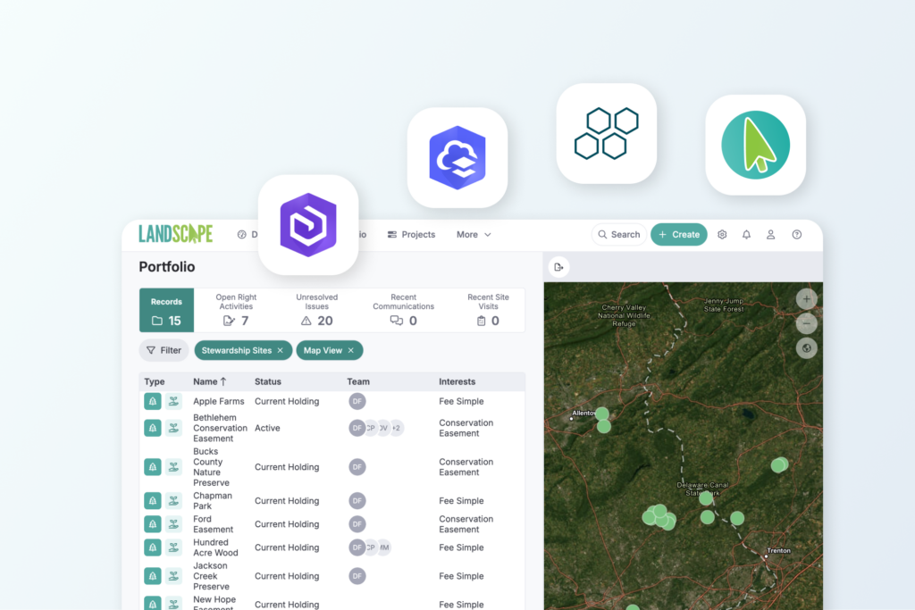
Our latest release centers on connecting Landscape with the other tools you use. The updates include major upgrades to our Lens integration, new ArcGIS Online and Enterprise integrations, a new Landscape API connection, and a faster way to import your portfolio. The integrations are available as part of a new subscription option – the Connections Add-On – which allows you to add advanced features to your existing subscription.
Upstream Tech Lens Integration – Now with Live Streaming & Imagery
We’ve expanded our Lens integration to streamline and organize remote monitoring.
Existing integration enhancements
Renamed the Lens Notes integration, the integration that is available as part of standard annual subscriptions now includes several new features. You can now instantly view a live list of Lens Notes in Landscape – no syncing required. Each property has a dedicated Lens page to keep things organized. You can then decide what you do with your Len Notes: create work from a single note, compile several notes into work, and create custom remote monitoring reports that include your observations.
This new workflow allows you to choose how you organize your data and gives you the ability to easily track remote monitoring in the same system as your in person site visits.
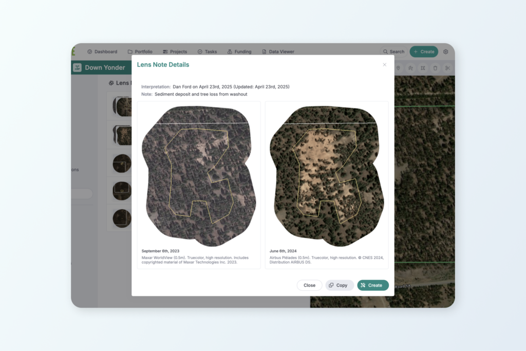
New Lens Imagery Integration
With the new Lens Imagery integration, you can display imagery that you purchase in Lens on Landscape interactive maps and in reports, giving you a seamless experience from observation to reporting. In addition to the benefit of giving your entire team access to the latest imagery on Landscape maps, you can also show your observations overlayed on the relevant imagery in your reports.
Here are a few examples of how you might use the Lens integration:
– Build complete remote monitoring reports by compiling custom forms, time tracking, property details, and observations on a satellite imagery map
– Track and resolve issues including communications back and forth with the landowner and generate a report that shows observations on current imagery
– Ground-truth remote monitoring observations using the Landscape Mobile App
The Lens Notes Integration is part of the standard annual subscription to Landscape. Imagery streaming with the Lens Imagery Integration can be added to your subscription with the Connections Add-On.
If you are interested in setting up the integration with Lens, contact Support to get started.
New Esri ArcGIS Integration
With the new Esri ArcGIS Online/Enterprise integration you can connect the tools you are used to using in GIS with your Landscape data.
The integration provides two main functions: sync your feature service of property boundaries to Landscape and add private feature service layers to Landscape.
You can maintain authoritative property boundaries directly in ArcGIS Pro and host them as a private feature service in your ArcGIS Online or Enterprise account. Edits made in ArcGIS Pro sync to Landscape, allowing you to continue working where you’re most comfortable. Boundaries appear as read-only layers in Landscape for consistent visualization across your team.
You can also now add secure, authenticated map services to Landscape. Host your own private vector or raster layers – like priority areas, management zones, or high-resolution imagery – and display them in Landscape maps. This gives you full control over your geospatial data while keeping it protected and accessible only to authorized users.
The Esri ArcGIS Online/Enterprise integration is available as part of the Connections Add-On.
New Landscape API
The launch of our Landscape API marks a major step forward in making your data more accessible and flexible. This allows you to use Landscape data in external software tools without the need to constantly export static files. You can now stream both tabular and spatial data directly from Landscape into your favorite applications. Simply create a View, generate a unique URL, and use it to connect live data to other applications. This keeps your external tools in sync with the latest data from Landscape in real time.
Here are just a few ideas for ways you can use the Landscape API:
– Create maps or run geospatial analyses using Landscape spatial data in tools like ArcGIS Pro or QGIS
– Set up automated email alerts with services like Zapier, triggered by changes in your data
– Feed live data into your CRM or other internal systems to keep property or project records up to date
Get Access to These New Features
You can get access to these new features – Lens Imagery streaming, the ArcGIS Online/Enterprise integration, and the Landscape API – with the Connections Add-On. This add-on unlocks integrations with tools your team already uses, streamlines your workflows, keeps data in sync across systems, all while maintaining full control over your data.
The Connections Add-On is available for $1,649 ($1,499 for nonprofits) per year. Contact Support today to get started.
Other Updates: Portfolio Importer
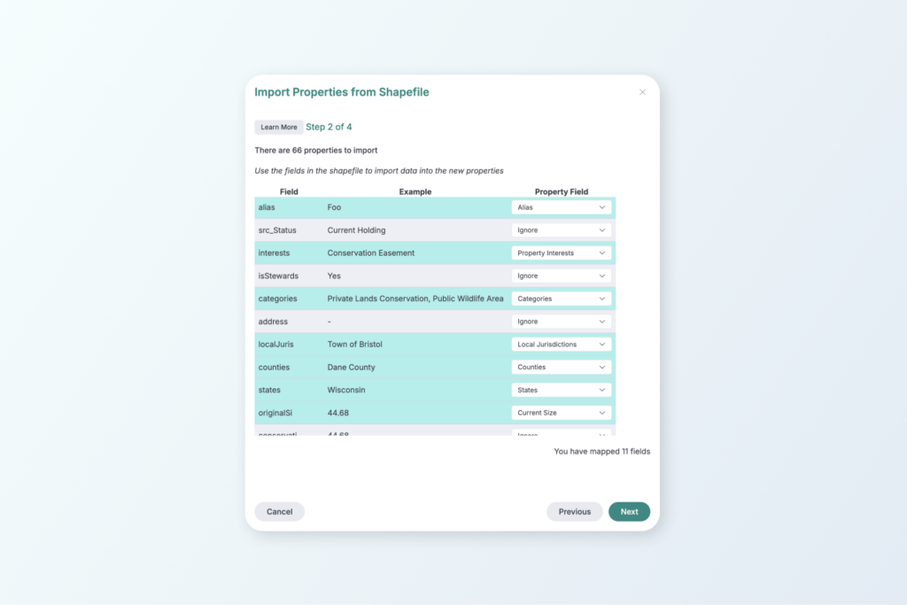
If you’re just getting started with Landscape, the Portfolio Importer makes it easy to create a large number of Property records all at once. Upload a shapefile that includes the boundary and details for multiple properties, match its attributes to Landscape’s Property and Contact fields, and create fully populated records in just a few clicks. It’s the perfect tool for onboarding large land portfolios quickly and accurately, saving you time, and reducing manual data entry.
This feature is included with the standard annual subscription.
Always innovating and improving
We’re constantly working to make Landscape the best comprehensive tool for land conservation work. Always feel free to send us your suggestions for improvement by sending a message to support. We appreciate your feedback – it helps us to help you!
New to Landscape?
Working in Landscape connects your team and organizes your work and reports. The best way to see how Landscape can help your organization is by seeing a demo. Sign up for a demo today!