October was a map month. The map layer style menu got an overhaul, you can turn a layer’s labels off without hiding the layer, and Landscape Mobile 4 on iPhone, iPad and Android now draws your styled layers exactly the way the web does, with a legend to explain them. Here’s what’s new since our last update.
A new map style menu
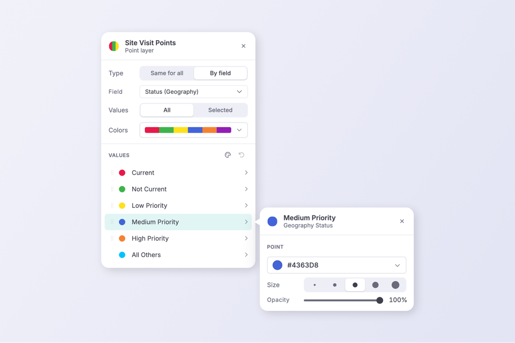
Every layer in the map’s layer list now has a single style menu. Click a layer’s swatch and you can change its color, line and fill in place, with the color picker built right into the menu.
When you style a layer by a field, such as Property Type or Last Monitored year, the menu lists each value with its own swatch:
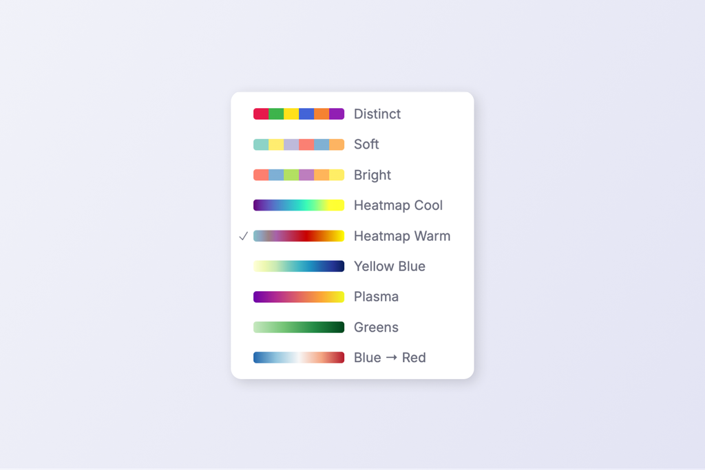
- Pick a palette and apply it to all values at once, or reset back to the defaults.
- Search the values to find the one you want on a long list, and adjust any single value from its own menu.
- Show or hide individual values. A layer shows as partly checked when only some of its values are on the map.
- Style by field on “All” is now the default, so every value gets its own color automatically. Layers support up to 24 values.
- Style ArcGIS service layers by their own fields, with the values read straight from the service.
The layer’s swatch keeps its shape (point, line or area) when it’s styled by field, and a selected feature’s icon now uses the same color the map draws it in.
A legend on the map
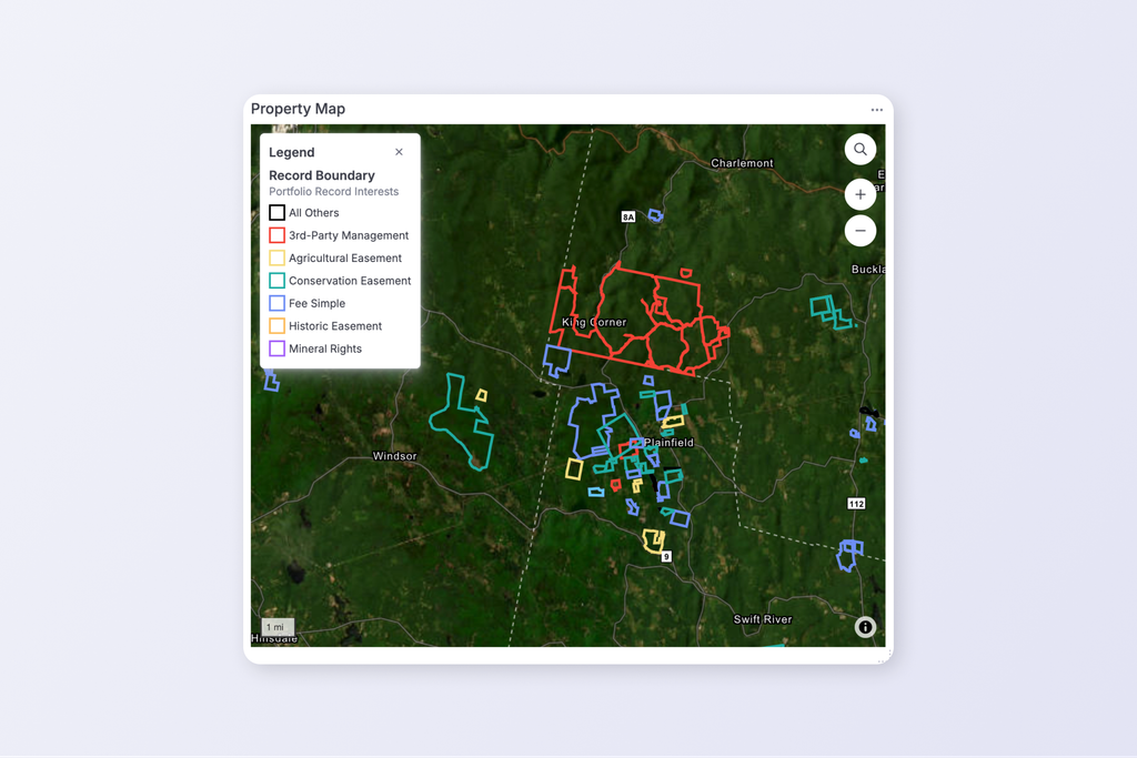
Interactive maps on dashboards and on your public map now have a legend. It lists layers in the same order as the layer list, grouped by category, and names the field each layer is styled by. It opens from a button in the top-left corner of the map.
Your styles, on Landscape Mobile 4
Landscape Mobile 4 for iPhone, iPad and Android now draws layers styled by a field exactly as the web map does: the same colors per value, the same date groups, and the same automatic “All” palettes. A style you set on the web is the style your field staff see on their phones.
Mobile 4 also has its own legend. You’ll find it in the layers list, in a work item’s new Map Layer Styles section, and by long-pressing a map toggle in a work list.
Turn map labels on and off, layer by layer
A busy map can bury its features under their names. You can now hide a layer’s labels without hiding the layer itself. Open the layer’s ⋯ menu and turn labels off, or do it for a whole group or section at once. A small tag appears beside any group with hidden labels, so you can turn them back on later.
The setting saves the way layer visibility does:
- On record and project maps, it’s saved for you, so each person can set up the map the way they like it.
- On views, dashboards, report templates and report maps, it’s saved with the map, so everyone sees the same thing.
- In Settings > Layer Styles, an administrator can set the account default.
Report templates benefit the most. Turn labels off in a template, and the reports it generates print clean maps. Need a name after all? A generated report’s map can still turn its labels back on.
On Landscape Mobile 4 for iPhone and iPad, labels are now positioned from each boundary itself, so they sit where you’d expect on the map.
More from October
Set a photo’s direction on a compass
Choosing which way a photo was taken is now visual. The direction input opens a compass dial you can drag, or step with the arrow keys, and a 60-degree cone shows what the camera saw. The eight main directions are one-click chips. For a photo on a point, the dial sits over aerial imagery centered on that point, so you can line the cone up with what’s actually in the frame.
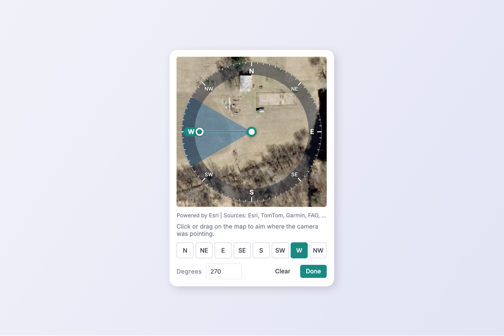
Drone photos get a direction too. Photos imported from DJI drones now take their heading from the drone’s own flight data, instead of coming in as “No Direction”.
Alerts when a photo never arrives
If a photo taken in Mobile 4 hasn’t finished uploading a day later, Landscape now alerts the person who took it and the property’s lead by email. The alert names the property and the work item, and suggests syncing over Wi-Fi, so missing photos get noticed while they’re still on the phone.
Your views in ArcGIS and QGIS
Any saved view can now be published as a live map feed that ArcGIS and QGIS can read (OGC API – Features). Open a view’s Landscape API URL dialog, add the view to the feed, and copy your account’s feed URL into your GIS. Your GIS layers stay current with Landscape, with no exporting.
This feature requires the ArcGIS Add-On to your subscription. Please let us know if you would like to try the ArcGIS integration for free by contacting Support.
Maps that filter your lists
On the Portfolio and Projects pages, moving the map now filters the list to what’s on screen, and the other tabs follow along. The map and the list always count the same records.
A tidier map toolbar
The record map’s toolbar is shorter. Measure and 3D terrain now open small drawers that hold their related tools.
Report template editing
- Choose report fields from a two-pane list grouped by category, and insert a field with a single click.
- Copy a report block instead of rebuilding it.
- Set each page margin separately, in centimeters for Canadian accounts.
- Edit a block’s filters in a dialog that summarizes them like the Data Viewer.
Work settings and forms
Settings has a new Work page for the built-in work categories, and each category can now have its own Status list. Add Form can link an existing form as well as create a new one, with search and a preview. Option lists and Types gain a Sort A–Z button.
Small things that add up
- New alerts arrive right away, instead of on a 30-second check.
- Text filters in Views default to Contains rather than Is, and the filter value list has a Done button.
- Budgets are offered for an expense wherever a project’s budgets apply.
- Work item attachment downloads are named for the work item.
- Photo thumbnails load faster and lighter on the web and in reports, and rotated photos get a correctly rotated thumbnail right away.
- Acquisition details are hidden from Portal users on the web and from Portal, Mobile-Only and Dashboard users in Mobile 4.
Landscape Mobile 4
Beyond map styles and the legend, this month’s Mobile 4 updates focused on making field work dependable:
- Time entry for several people at once, and alongside a running recording.
- New work links to a recording and copies its geometry.
- Photos record the direction the camera faced more accurately, and take the date and location from the moment of capture. Each photo in a series keeps its own location, and a photo picked from the library keeps its original GPS.
- Drawing asks before discarding unsaved shapes, no longer drops a point when you tap to stop a moving map, and a geography can be deleted from its tray.
- Contacts from related records appear once each on a record’s Contacts tab.
- Sync and uploads are sturdier on weak connections: a failed step retries in place instead of starting over, and the app tells you when an update is required.
- Support diagnostics upload automatically, so our team can help faster when something goes wrong.
Update Landscape Mobile 4 from the App Store or Google Play to get the latest
Keep the feedback coming
Many of this month’s changes started as a note from one of you. If something in Landscape could work better, please reach out to Support!
New to Landscape? Book a demo and see how land trusts manage their properties, stewardship and field work in one place.