Powerful, user-friendly, and affordable
Landscape brings efficiency and organization to your team, so you can focus on conservation.
Get started with Landscape today
Manage your entire process of land conservation, from acquisition project management to ongoing stewardship – all in one tool.
- Unlimited Users
- Mobile app for field data collection
- 100 GB document storage
- Email and phone support
- Regular feature enhancements
Standard Nonprofit
Designed for organizations managing an active portfolio with pricing based on the total number of properties you protect and manage.
$ 849
Base $989 per year includes 50 properties + $41 per month per additional 50 properties. Unlimited users.
Integrate with your other tools
File storage, CRM, and data integrations are included with the Standard subscription. You can also add advanced integrations to share data between Landscape and other tools.
Standard Integrations
Share data between Landscape and other tools with direct integrations or our robust API.
Included with Standard Subscription
Free
File Storage



Contacts and Communications

Data and Visualization


Esri ArcGIS Integration
Designed for teams with dedicated GIS professionals who want to gain efficiency by connecting your ArcGIS Online or Enterprise account to Landscape.
Annual Subscription
$999
/ year


- Maintain property boundaries in ArcGIS Pro, sync to Landscape
- Add private authenticated feature services to Landscape
- Stream your Landscape data to ESRI apps with the Landscape API
Contact us to add this to your subscription
Upstream Tech Lens Imagery Integration
Built to streamline your remote monitoring process by connecting Lens satellite imagery and observations with your other property data
Annual Subscription
$499
/ year

- All Lens Notes Integration features*
- Give your entire team access to the latest imagery
- Display Lens imagery on Landscape interactive maps
- Print reports with maps of Lens imagery
Contact us to add this to your subscription
Get started with Landscape today
Manage your entire process of land conservation, from acquisition project management to ongoing stewardship – all in one tool.
- Unlimited Users
- Mobile app for field data collection
- 100 GB document storage
- Email and phone support
- Regular feature enhancements
Standard
Designed for organizations managing an active portfolio with pricing based on the total number of properties you protect and manage.
Properties
$ 1,949
Base $1,949 per year includes 50 properties + $41 per month per additional 50 properties. Unlimited users.
Integrate with your other tools
File storage, CRM, and data integrations are included with the Standard subscription. You can also add advanced integrations to share data between Landscape and other tools.
Standard Integrations
Share data between Landscape and other tools with direct integrations or our robust API.
Included with Standard Subscription
Free
File Storage


Contacts and Communications


Data and Visualization


Esri ArcGIS Integration
Designed for teams with dedicated GIS professionals who want to gain efficiency by connecting your ArcGIS Online or Enterprise account to Landscape.
Annual Subscription
$999
/ year


- Maintain property boundaries in ArcGIS Pro, sync to Landscape
- Add private authenticated feature services to Landscape
- Control data privacy while allowing your team to visualize data on Landscape maps
Contact us to add this to your subscription
Upstream Tech Lens Integration
Built to streamline your remote monitoring process by connecting Lens satellite imagery and observations with your other property data
Annual Subscription
$499
/ year

- Display Lens imagery on Landscape maps and in reports
- Give your team access to the latest imagery
- Show observations directly on up-to-date imagery in reports
Contact us to add this to your subscription

Scalable tools for protection and stewardship
Built for large portfolios and multi-office collaborations, our Enterprise plan includes everything in Standard, plus:
- Advanced permissions and user management
- Integrate with your internal systems to build custom workflows
- Personalized setup and support from our team
- Unlimited document storage
- Priority support and training
Enterprise
Custom pricing based on your portfolio size, integrations, and support needs.
- More than 2,000 properties?
- Need to segment your data across multiple offices?
- Need a service level agreement?
We’ll work with you to build a plan that fits your organization’s structure and goals.
Hit the ground running
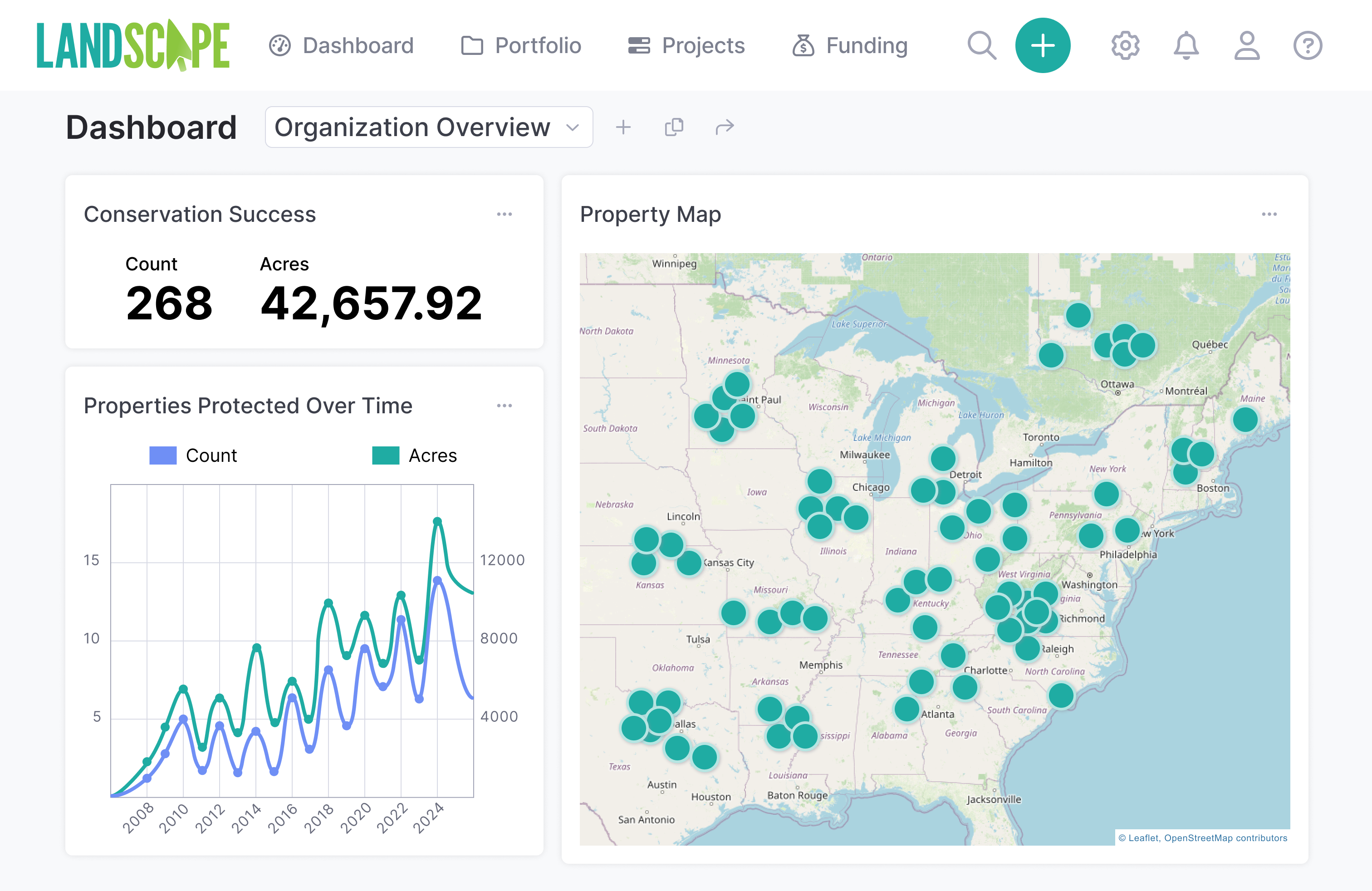
Enter your data record-by-record, import map data to create a Portfolio, or take advantage of our onboarding service to start with your data in place on day one.
Continue your current work while collecting organized data using comfortable and efficient workflows.
Connect with a Landscape Data Specialist to learn which option is best for you.


Texas Land Conservancy
“Landscape has changed how we manage our stewardship data. Instead of searching through folders of excel sheets and word documents, we now have all our easement and property data in one place. We couldn’t be more pleased with Landscape!”

County of Chester
"Landscape is a game changer – with everything we need for inspections housed in one place and accessible through an easy-to-navigate user interface, we have been able to simplify our workflow and dramatically increase our efficiency in the office and in the field."
Frequently Asked Questions
There are a few of ways to set up a Landscape account with your existing portfolio of properties:
- Manual Entry: enter your data for each Property one-by-one and get a great hands-on tour of Landscape.
- Import a shapefile of property boundaries: use our Portfolio Importer tool to create many properties from a spatial data file of your property boundaries.
- Leverage our Onboarding Service: we’ll set up your account with your portfolio data. This service starts at $700 and goes up based on the complexity of the data that you would like imported. Document uploading is typically not included as a part of this service. The Onboarding Service also comes with 3 one hour training sessions to get your team started.
From there, your team can configure settings and customize settings, including report templates, data dropdowns, and forms. Most organizations can get up and running within a few days of starting with Landscape.
You can start collecting and editing data on Day One in Landscape!
For organizations who don’t want to enter their data by hand, we offer an onboarding service at an hourly rate. This includes:
- Consultation about data structure in Landscape and how your data can best fit within the Landscape framework. You send or give us access to your digital data (spreadsheets, shapefiles, Access databases, etc.).
- Importing of the following data:
- Property data
- Contact data
- Monitoring Data
- GIS/map data
- Three one-hour follow-up training sessions, covering whatever you need, but most often touching on Stewardship, Projects, and the Mobile App. We find that organizations often have a number of questions as they’re just getting started which can be most easily answered in a screen-share meeting format.
Any data imports requested after the initial onboarding process are available for an additional hourly fee.
In addition to our ever-expanding Knowledge Base, which includes videos and how-to articles, we are just a quick email or phone call away. We are always happy to answer your questions. We constantly incorporate user feedback into our feature development.
Landscape is built on a world-class cloud server platform (Microsoft Azure). All data is backed up and/or stored redundantly in multiple locations, meaning a catastrophic failure of one server will not result in the loss of your data. For peace of mind, you can also periodically download data to your local server at your convenience.
All your data is password protected and all communications between your web browser and the server is encrypted using the latest standard encryption technology.
See Landscape in action
The best way to understand how Landscape works is to schedule a demo and see it in action!